
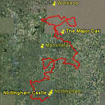
Introduction
This is an account of how I walked the whole of the Robin Hood Way (also shown as the Way or RHW) in Nottinghamshire over a period of 29 months. I planned the whole walk so that each leg could be accomplished in approximately half a day, and that each leg was either circular or a return could be made to the starting point by public transport. I walked the 110 miles of the route in 18 sections and to accomplish this I walked a further 40 miles, and used public transport on 5 legs. The official route starts in Nottingham by the castle and ends at the Major Oak in Sherwood Forest, with several diversions along the way.
My interest started by wanting to combine my regular walking hobby with a longer term goal, and the idea of walking the whole of the RHW seemed a natural as I live in a house that is 6 doors away from part of the route in Nottingham. I spent some time trying to plan the sections in detail to tie in with my objectives of circularity or the availability of public transport to return to the starting point, and to restrict each walk to a maximum of 4 hours. This became more and more difficult for those legs in the wilds of rural Nottinghamshire, even though I did not restrict myself to walking the legs in the same direction.
10th October 2006
14.5m (RHW 13.9m)
4h 5m
3h 35m.
This was the first truly circular walk without any use of public transport. I parked in Blidworth village and set off across the fields towards Ravenshead and Newstead Abbey. Early on in the walk I had to take a large diversion around the edge of a field as I neared Ravenshead, as the farmer was busy ploughing the field and it was impossible to follow the true line of the RHW. From Ravenshead the Way goes southwest to Papplewick and then follows a long stretch through Newstead Abbey grounds affording good views of the Abbey as it goes north. From Newstead Abbey the route back to Blidworth passes through features with ancient-sounding names - Nomanshill Wood, Thieves Wood, Fountain Dale, and Friar Tuck's Well. I never did actually find the latter as it seems to be buried in the ancient and tangled woodland which lies around it.
2h 50m.

Trailblazing!
To start this walk, I drove to Southwell and parked in the Car Park opposite the Minster, timing my arrival so that I could catch the infrequent bus to The White Post. In fact, I arrived early and had time for a coffee in a local cafe before catching the bus. The route passes across fields (again, recently ploughed, as can be seen from the photograph above) towards Farnsfield and then turns south towards Robin Hood Hill. At Coombs Wood it would be possible to take a diversion, still on the RHW, to Robin Hood Hill, but I decided to leave this section for another day and completed it over 2 years later on Walk 16.

Taking the diversion would add approximately another 2 miles to this walk. Instead I turned east which took me down some very pretty green lanes and past the only plaque I discovered on the whole of the walks......

This plaque is situated at approximately the mid point of the RHW between Nottingham Castle and the Major Oak and lies at one of the highest points on the Way. The route from here to return to Southwell passes through Halam and then diverts around the fields to the south of Southwell to finally pass through the Minster precincts.
8.7m (RHW 6.53m)
This walk is totally within the city of Nottingham but passes through some of the best landscapes to the west of the city. It follows the Robin Hood Way from the Parkside Gates of Wollaton Park through the park to the Lodge on Derby Road (or Brian Clough Way now) and crosses into the University grounds. There the RHW goes south to the lake and then follows the paths through the Rhododendrons and Azaleas to the childrens play area. After a short stretch along University Boulevard and a passage under the flyover the Way follows the Beeston Canal past Castle Marina and to the lock at the end of Queens Drive where it turns North to the Robin Hood Statue outside Nottingham Castle. It is here that the Robin Hood Way officially starts. The section along the canal comes through significant recent developments which now make it a very pleasant walk.
To return to Wollaton I elected to walk back through the The Park and then went down Abbey Road which picks up another loop of the Robin Hood Way which goes for a short while along the ring road to the main gates of Wollaton Park, From here the route follows Lime Tree Way and then past Wollaton Hall to Parkside.
Walk 6 - Southwell Circular via Kirklington
13th November 2007
12.66m (RHW 6.84m.
3h 14m.
For this, the second longest walk of the set, I drove to Southwell and parked again in the carpark opposite the Minster. In order to make this a circular route with a minimum of walking on roads, I followed the Robin Hood Way through Kirklington and then to Roe Wood which is well on the way to Eakring, hence the longer distance.
From the car park in Southwell the RHW passes east through fields and urban roads and then turns west towards the start of the Southwell Trail. However, it does not follow the trail at this point but goes parallel to it by crossing the bridge by the factory and then following the north bank of the stream to Maythorne Farm and the fishponds. From here the Southwell Trail is picked up for a mile or so until the RHW turns north through Kirklington and then across farmed fields to Roe Wood.
For this walk this is the end of the RHW and to return to Southwell I went east round the edge of Roe Wood to Winkburn and then followed the paths south across the A617 and Corkhill Lane until I arrived back at Maythorne Farm.

Some of the paths near the A617 appeared to be very little used and at the time when I did the walk the footbridge just off the A617 was in a sorry state of repair, as can be seen from these photographs!
Having reached the farm again, I took paths across fields to pick up Kirklington Road by Norwood Park Golf Course which led me back into Southwell and the car park.
7.07m (RHW 6.9m)
2h 33m.
All but the last couple of hundred yards of this walk lie on the Robin Hood Way. I parked in a layby on the A614 near the entrance to Clumber Park just south of Clumber Park Hotel. The walk is totally rural and goes east and northeast through woods and fields to the village of Elkesley having passed by Spitfire Bottoms and Spitfire Hill (I can't find out the source of the name). From Elkesley there is a long straightish stretch of the RHW for approx. 2.5 miles through Beggars Rest and near the farms of Haughton Kennels, Haughton Park House and Haughton Hall.

Eventually turning west, a large free range chicken farm is passed containing a vast amount of very friendly chickens!

After Beards Belt, the route turns northwest via the wild Blackcliffe Hill Plantation (seen here in the photo) and in a short while reaches the A614 and the start.
2h 18m.

To get to the start of this walk I drove to Ollerton and parked behind the shops near Tesco. The bus to Eakring leaves from outside Tesco and there is a bus-stop outside the pub in Eakring right on the Robin Hood Way. From here the path is fairly poorly defined across fields until eventually Rufford Park Golf Course is reached. Following this the route skirts Rufford Abbey, crosses the A614, and passes the entrance to Center Parcs. It was just after Center Parcs that I passed the site of an enormous leek field in which a multi-person, travelling, leek-picking vehicle/tent was operating as shown in the picture. In one end leeks in the ground - out of the other, washed, trimmed and packed fresh leeks! From here on the route is quite clear across field paths and I followed the RHW as far as the River Maun. To return to Ollerton and my car I then needed to walk over 5 miles back through the outskirts of Edwinstowe, along the railway line, and through Old Ollerton to the car park.
2nd September 2008
8.44m (RHW 7.63m)
2h 16m.


This walk more or less takes over from where the previous walk left off. After parking in Edwinstowe, a short walk through the edges of the village took me back to the River Maun where I could pick up the RHW again. The river is followed west for a short way and then the route turns northwest past Archway House. It was built as part of a plan by the Duke of Portland in the mid 1800s to create a route from Welbeck Abbey to Nottingham, but it never got further than here, the Duke having decided that rail travel was a better bet! Apparently, at one time, the Centre Oak, which is passed later on in this walk (as well as the Major Oak), could be seen through the arch.

The RHW from here veers west around the edge of the forest and then turns north for some 3 km along one of the many defined routes through the forest. A short walk east, picking up the spur of the RHW that leads to the Major Oak, reaches the corner of Budby South Forest where the route turns south. On a clear and sunny day the walk through this part of the forest is splendid with views across the heather and scrub covered landscape. When the Centre Oak is reached the RHW turns west on a straight line to the Major Oak, pictured here. From here, the RHW carries on through the well-trodden tourist routes to the Visitor Centre and then on to the centre of Edwinstowe where it ends, with a short walk back to the car park.
6.31m (RHW 2.87m)
1h 45m.

I planned this walk to pick up the 3 miles of the Robin Hood Way that I had missed between Walk 6 Southwell Circular and Walk 8, Eakring to Ollerton, although this meant a further 3 miles of walking to complete the circle. I drove to Pudding Poke Wood parking place and discovered to my surprise that this area was the site where oil wells were drilled in the 1940s and is now a museum site. There is a trail defined through Pudding Poke Wood and its neighbour Duke Wood which passes the remains of the nodding donkey wells and takes in the flora and fauna of the area and goes past the Museum. Details of this trail are given at http://www.dukeswoodoilmuseum.co.uk/ . Maybe I'll visit properly at a later date. However, my route to pick up the RHW bypassed the trail and its scenery and went southeast through Nut Wood to the edge of Roe Wood where I revisited part of the Way from Walk 6 before turning northwest back towards Eakring. Again I met some freshly ploughed and sown fields as shown above, but there was a very pleasant stretch through Dilliner Wood and across Manser Common. On reaching Eakring I followed the RHW through the fields to the west to arrive back at the pub where I started Walk 8. Unfortunately, there was no simple route back to my car at Pudding Poke Wood other than following the main road south out of Eakring for approximately 2 km.
14th December 2008
3.81m (RHW 1.31m)
1h 17m.
8.25m (RHW 3.38m)
2h 17m
I parked in Cuckney outside the cafe and shop and walked through the village and past the church with its Motte and Bailey (photograph in Walk 13). The morning was cold and frosty but bright and after a short walk north across fields the RHW is picked up on the outskirts of Norton and then followed through the grounds of Welbeck Abbey. The route passes the Deer Park where I saw many deer grazing (shown here). After passing through Tile Kiln Wood and near the stables and outbuildings of the Abbey the RHW takes a sharp turn southwest to cross the A60 and into Holbeck Village.
I presume the village is still part of the Abbey estate in view of its very neat and ordered layout and pretty church - seen here through its gate.
The Way passes through the village and then across fields and hills to eventually drop down in to the west end of Creswell Crags. The RHW turns east here through the crags but I turned west to the main A616 at the point shown in the photograph. The route through the crags is travelled in Walk 14. To return to Cuckney I attempted to pick up as many footpaths as poosible to avoid too much time on the main road. This was difficult at first as the first footpath to the west of the A616 shown on the map appears to go straight through a building and the alternative I picked meant walking across a field and through a hole in a fence! There is an alternative however if you go a further 200 metres down the main road to pick up the marked cycle route. Even going down the field paths as far as I could, I still had to take the A616 for the last mile or so back the car and a welcome bacon buttie and coffee from the cafe.
Walk 13 - Hazel Gap to Hazel Gap via Cuckney
14th January 2009
8.31m (RHW 4.56m)
2h 14m.
This was the first of the 2 walks which started at Hazel Gap, after parking in the small layby there. The first stretch follows the RHW through plantations as far as Corunna Lodge and then continues along the roads to Norton. On the latter section the RHW skirts the southern boundary of Welbeck Park with views of The Great Lake. I left the Robin Hood Way at Norton to make my way back to Hazel Gap, the return section being further than the outward journey. From Norton I took footpaths southwards to Cuckney, again going past the church and the Motte and Bailey. I then followed Sandy Lane south and, after a short section on the A60, I went east across the fields past the remains of Welbeck Colliery, where the old headstocks can be seen. After Meden Vale and a short walk through fields, I picked up the Robin Hood Way again and took a loop round Gleadthorpe Grange in order to cover both bits of the RHW that pass either side of the Grange, before returning to Hazel Gap.
Walk 14 - Creswell to Worksop
20th January 2009
9.57m (RHW 5.44m)
2h 48m.
This is the only walk which required the use of the train. I decided to drive to Worksop Station where I caught the hourly Robin Hood Line train to Creswell, which is 2 stops down the line towards Nottingham. The walk then became a linear walk back to Worksop, with the Robin Hood Way covering well over the first half of the walk.
The Way is picked up at the start of Creswell Crags, which lie a kilometre or so away from Creswell Station, and where I left the Way during Walk 12. The Crags and the prehistoric caves are now well landscaped and quiet after the bypass road has been completed, and the Way passes through these and by the Visitor Centre before crossing the A60 and into Welbeck Park. At the time I did the walk the Visitor Centre at the Crags was being rebuilt and the path took a slight detour through the woods near the Centre. The path through the park crosses the bridge at the northern end of Shrubbery Lake and then crosses the fields towards South Lodge, under which lies the tunnel that was built by a previous Duke as a private means of access to the Abbey. After South Lodge the RHW continues for the whole length of Drinking Pit lane to arrive eventually at Truman's Lodge and the entrance to Clumber Park. I followed the Way for a few hundred yards from this point before turning north, leaving the Way, to head back to Worksop. The path I took passes through woodland followed by a stretch through the middle of Worksop Golf Course before entering the estates on the edge of Worksop. There are many ways back to the station, but I followed one which ended up with a short walk along the Chesterfield Canal and the Cuckoo Way before taking the last quarter mile to the station.
Walk 15 - Hazel Gap to Hazel Gap via Clumber Park
11th February 2009
9.25m (RHW 6.25m)
2h 28m.
This was the second walk starting from Hazel Gap, after parking in the layby - this time going east to Clumber Park. The weather was quite chilly and there was a fair amount of snow and ice on the ground. The first stretch of the walk was virtually straight in a northeast direction for nearly 6 km, passing across the B6034 at Duncanwood Lodge and then through plantations to the south of Clumber Park until the A614 was reached. A large portion of this part of the route was on tracks that had been used by vehicles after the snow had fallen and, as a consequence, in the freezing weather, they had become covered in hard-packed snow and ice. This made walking difficult and it was necesssary to use the unpacked virgin snow at the edges of the paths to maintain a foothold.
After a short walk north on paths parallel to the A614 the RHW is rejoined near the entrance to Clumber Park opposite the Clumber Park Hotel. Between these 2 points on the A614 the Robin Hood Way has taken a long sweep eastwards through Elkesley and Haughton which I covered in Walk 7. The route I followed today then crosses the ford at Hardwick village and then follows the popular northern edge of Clumber Lake as far as the Visitor Centre and the remains of the house. Needless to say, as can be seen from the photograph, I was on my own today! I left the RHW at the Centre and followed paths through the Park towards Carburton Lodge where I picked up the road leading to the B6034. After a short walk south on the road, I took a footpath going southwest back to Hazel Gap.
Walk 16 - There and back to Robin Hood Hill
25th February 2009
4.1m (RHW 0.94m)
1h 16m.
This walk was designed to take in the spur of the Robin Hood Way that branches of the route I covered in Walk 7. Although this was a short and simple walk, it provided some of the best interest and views of all the walks. Having parked on the A616 by the Farm Shop the route went across lanes and past woods with wide ranging views across West Nottinghamshire (including all the free-range pigs!) and ended up at Robin Hood Hill which is an ancient Saxon Burial Mound. I believe this is also called Robin Hood's Pot as a pot of Roman coins has been found here. Just beyond the hill is a Bronze Age Settlement called Oxlow. The settlement's earthworks remain intact and the surrounding ditches and the settlement entrances can be clearly seen.
Robin Hood Hill
A view of the Southeastern entrance to Oxlow.

The Western ditch of Oxlow
A View of West Nottinghamshire
Walk 17 - Greasley Circular
26th February 2009
2.85m (RHW 1.88m)
0h 56m.
A very short walk, which took me under an hour starting from the layby at Greasley church. I covered the ground that I had missed in Walk 1 and also the spur of the RHW that takes in Greasley church. The walk was mainly across fields with a short section through woods.
Walk 18 - Blidworth to Blidworth via The White Post
4th March 2009
5.58m (RHW 2.31m)
1h 28m.
I left this walk till last as I anticipated that it would be quite boring! As it turned out, it wasn't too bad with some quite scenic stretches. I parked near the centre of Blidworth and followed the road east until the RHW turned off towards the White Post. This section was past woods and through fields eventually reaching the A614. At this point I had covered every single mile of the RHW. I decided that the bast way back from here to my car, without retracing my steps, was to walk by the Mansfield Road towards Rainworth, and the pick up the National Cycle Route No 6 going southwest back to Blidworth. A short walk through houses on the edge of Blidworth brought me back to my car.
So there ends the history of 18 walks, encompassing 152 miles in 44 hours.